
搜索结果: 1-15 共查到“accuracy”相关记录590条 . 查询时间(0.4 秒)

ANSPRE: A Method that Boosts the Accuracy Performance of Large Language Models(图)
ANSPRE Large Language Models the Accuracy Performance
2025/3/27
Researchers develop a new method that enables large language models to answer questions more concisely and accurately.
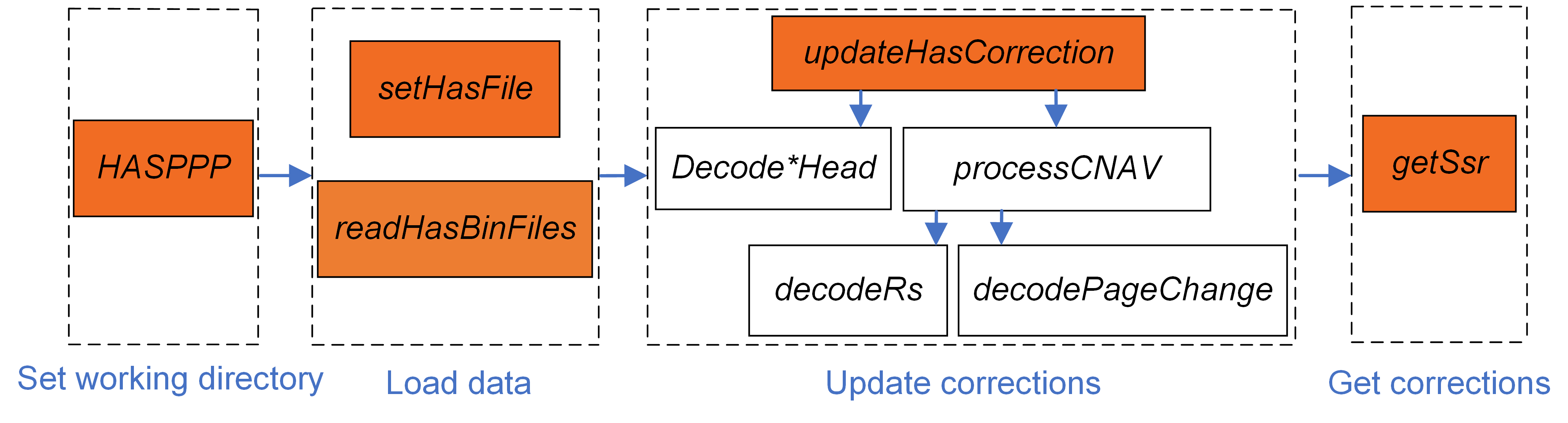
伽利略HAS服务旨在为全球用户提供星基精密单点定位(PPP)服务。自2023年1月24日起,伽利略正式提供初始服务,这是继北斗精密单点定位(PPP-B2b)服务之后的又一项星基增强服务。
Enhancing the Accuracy and Temporal Transferability of Irrigated Cropping Field Classification Using Optical Remote Sensing Imagery
irrigated field classification Landsat NDVI time series Gaussian mixture model interannual climate variability regional analysis
2023/12/1
Mapping irrigated areas using remotely sensed imagery has been widely applied to support agricultural water management; however, accuracy is often compromised by the in-field heterogeneity of and inte...
Leaf water potential measurements using the pressure chamber: synthetic testing of assumptions towards best practices for precision and accuracy
leaf water potential plant water relations plant water status pressure bomb pressure chamber water stress
2023/11/28
Leaf water potential (ψ leaf), typically measured using the pressure chamber, is the most important metric of plant water status, providing high theoretical value and information content for multiple ...
Lithography-free photonic chip offers speed and accuracy for AI(图)
Artificial Intelligence Electrical Computer Engineering
2023/6/27
Photonic chips have revolutionized data-heavy technologies. On their own or in concert with traditional electronic circuits, these laser-powered devices send and process information at the speed of li...

Algorithms developed in Cornell’s Laboratory for Intelligent Systems and Controls can predict the in-game actions of volleyball players with more than 80% accuracy, and now the lab is collaborating wi...

A new way to perform "general inverse design" with high accuracy(图)
通用逆设计 SMART 特性识别材料 机器学习
2023/6/7
Researchers have discovered a novel way to perform “general inverse design” with reasonably high accuracy. This breakthrough paves the way for further development of a burgeoning and fast-moving field...
A COMPARATIVE STUDY AMONG THREE REGISTRATION ALGORITHMS: PERFORMANCE, QUALITY ASSURANCE AND ACCURACY
Accuracy Automation Least Squares Registration'Terrestrial Laser Scanning
2019/3/4
A critical task in every terrestrial laser scanning project is the transformation (addressed to as registration or alignment) of multiple point clouds into a common reference system. Even though this ...
COMPARISON WITH ACCURACY OF TERRESTRIAL LASER SCANNER BY USING POINT CLOUD ALIGNED WITH SHAPE MATCHING AND BEST FITTING METHODS
laser scanning time of flight phase shift shape matching natural distributions Ostia
2019/3/4
Recently operation systems of laser scanning have been obviously improved; for instance shape matching has been equipped with software on a post processing stage so measurement without any targets is ...
ACCURACY ASSESSMENT OF 3D MODELS GENERATED FROM GOOGLE STREET VIEW IMAGERY
Spherical Photogrammetry Equi-rectangular Panoramas Accuracy
2019/3/1
Google Street View is a technology implemented in several Google services/applications (e.g. Google Maps, Google Earth) which provides the user, interested in viewing a particular location on the map,...
Jitter Estimation with High Accuracy for Oscillator-Based TRNGs
TRNG ring oscillator jitter
2018/11/6
Ring oscillator-based true random number generators (RO-based TRNGs) are widely used to provide unpredictable random numbers for cryptographic systems. The unpredictability of the output numbers, whic...
IDENTIFICATION OF LOW ACCURACY REGIONS IN LAND COVER MAPS USING UNCERTAINTY MEASURES AND CLASSIFICATION CONFIDENCE
Multispectral images Classification Uncertainty Confidence Accuracy Spatial variation
2018/11/9
The aim of this article is to assess if the data provided by soft classifiers and uncertainty measures can be used to identify regions with different levels of accuracy in a classified image. To this ...
LANDFORM PERCEPTION ACCURACY IN SHADED RELIEF MAPS: A REPLICATION STUDY CONFIRMS THAT NNW LIGHTING IS BETTER THAN NW AGAINST THE RELIEF INVERSION EFFECT
Relief inversion effect Terrain reversal effect Shaded relief maps
2018/11/9
Relief inversion effect is a perceptual phenomenon that leads to an inverted perception of convex and concave shapes. This perceptual inversion occurs in scenes where the shading/shadows act as the ma...
AN OPEN SOURCE APPROACH FOR THE INTRINSIC ASSESSMENT OF THE TEMPORAL ACCURACY, UP-TO-DATENESS AND LINEAGE OF OPENSTREETMAP
Data Quality Lineage Open Source OpenStreetMap Temporal Accuracy Thematic Accuracy Up-to-dateness
2018/11/8
OpenStreetMap (OSM) is the most popular crowdsourced geographic information project. The main factor that still limits the practical use of OSM is the lack of quality assurance. OSM quality assessment...
AN INTERFEROMETRIC PROCESSING METHOD TO MAINTAIN BOTH ACCURACY AND RESOLUTION OF DEM USING GAOFEN-3 SAR DATA
Gaofen-3, TanDEM-X, DEM, multi-look
2018/5/14
Gaofen-3 (GF-3) is the only in-orbit SAR satellite of China civilian fields. It is designed especially for ocean observation but not for interferometric applications. However, during the past one and ...