搜索结果: 1-9 共查到“海洋科学 Maps”相关记录9条 . 查询时间(0.125 秒)

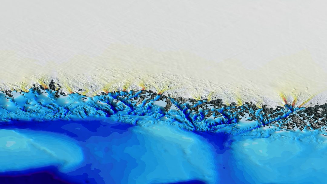
New maps of Greenland’s coastal seafloor and bedrock beneath its massive ice sheet show that two to four times as many coastal glaciers are at risk of accelerated melting as had previously been though...
Seamount Catalog:Seamount Morphology,Maps,and Data Files
Seamount Catalog Seamount Morphology Maps Data Files
2015/7/7
Seamount research, more often than not, is carried out by highly specialized science teams with narrowly focused science objectives. As a result, different seamount science disciplines often do not co...
Maps from the Mid-Ocean Dynamics Experiment:Part II. Potential vorticity and its Conservation
Mid-Ocean Dynamics Experiment Conservation Potential vorticity
2009/3/7
Observations of float trajectories and vertical density profiles from the Mid-Ocean Dynamics Experiment are analyzed in terms of a likely equation of motion for mesoscale eddies involving the conserva...
Maps from the Mid-Ocean Dynamics Experiment:Part I. Geostrophic Streamfunction
Mid-Ocean Dynamics Experiment Geostrophic Streamfunction
2009/3/7
From measurements made during the 1973 Mid-Ocean Dynamics Experiment in the western North Atlantic, horizontal maps of the total dynamic pressure (or, in the geostrophic approximation, streamfunction)...
The Ventilation of the World’s Oceans:Maps of the Potential vorticity Field
World’s Oceans Potential vorticity Field
2009/1/15
Maps of potential vorticity (q) within four different density layers are presented for the North and South Atlantic, North and South Pacific, and Indian Oceans. Potential vorticity is evaluated as (f/...
Tomographic Maps of the Ocean Mesoscale. Part 1:Pure Acoustics
Tomographic Maps Ocean Mesoscale Pure Acoustics
2009/1/15
A field test of ocean acoustic tomography was conducted in 1981 for a two month period in a 300 km square at 26°N, 70°W in the North Atlantic (just south of the MODE region). Nine acoustic deep-sea mo...
Improvement of Tomographic Maps by Using Surface-Reflected Rays
Tomographic Maps Surface-Reflected Rays
2009/1/8
The results of the experiment conducted in the northwest Atlantic in 1981 have demonstrated the possibilities of acoustic tomography. The first maps, based only on purely refracted rays, showed the ev...
Direct Atmospheric Forcing of Geostrophic Eddies. Part II:Coherence Maps
Coherence Maps Geostrophic Eddies atmospheric forcing
2008/12/11
The theory of stochastic atmospheric forcing of quasigeostrophic eddies is applied to calculate coherence maps, that is, the coherence between the oceanic response at one location and the atmospheric ...
Coherence Maps for Wind-Forced Quasigeostrophic Flows
Fleet Numerical Oceanographic Center Wind-Forced Quasigeostrophic Flows
2008/11/26
Coherence maps are a useful tool to study the oceanic response to atmospheric forcing. For a specific frequency band these maps display the coherence between the oceanic current (or pressure) at a sin...

