
搜索结果: 1-15 共查到“遥感信息工程 imaging”相关记录28条 . 查询时间(0.25 秒)
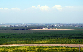
Researchers use satellite imaging to map groundwater use in California's Central Valley(图)
satellite imaging map groundwater California Central Valley
2020/10/16
Researchers at the University of California, San Diego report a new way to improve groundwater monitoring by using a remote sensing technology, known as InSAR (interferometric synthetic aper...
FUSION OF LASER ALTIMETRY DATA WITH DEMS DERIVED FROM STEREO IMAGING SYSTEMS
Ice Sheet Surface Elevation Changes Fusion System Mass Balance Changes
2016/11/30
During the last two decades surface elevation data have been gathered over the Greenland Ice Sheet (GrIS) from a variety of different sensors including spaceborne and airborne laser altimetry, such as...
EVALUATION OF VARIOUS SPECTRAL INPUTS FOR ESTIMATION OF FOREST BIOCHEMICAL AND STRUCTURAL PROPERTIES FROM AIRBORNE IMAGING SPECTROSCOPY DATA
Airborne imaging spectroscopy DART Chlorophyll content Continuum removal Leaf area index Forest Support vector regression Radiative transfer modelling
2016/11/24
In this study we evaluated various spectral inputs for retrieval of forest chlorophyll content (Cab) and leaf area index (LAI) from high spectral and spatial resolution airborne imaging spectroscopy d...
ACCOUNTING FOR VARIANCE IN HYPERSPECTRAL DATA COMING FROM LIMITATIONS OF THE IMAGING SYSTEM
Supervised classification decorrelation Mahalanobis distance Signal-to-noise ratio (SNR) Bayesian approach Principal component analysis Pixel-wise calibration
2016/11/23
Over the course of the past few years, a number of methods was developed to incorporate hyperspectral imaging specifics into generic data mining techniques, traditionally used for hyperspectral data p...
POTENTIAL OF AIRBORNE IMAGING SPECTROSCOPY AT CZECHGLOBE
Imaging Spectroscopy Hyperspectral sensors Airborne platform Pre-processing chain
2016/7/4
Ecosystems, their services, structures and functions are affected by complex environmental processes, which are both natural and human-induced and globally changing. In order to understand how ecosyst...
ATMOSPHERIC CORRECTION ITERATIVE METHOD FOR HIGH RESOLUTION AEROSPACE IMAGING SPECTROMETERS
Atmospheric Correction Imaging Spectrometers Remote Sensing Hyper Spectral Images Environmental Monitoring
2015/12/31
The increasing radiometric accuracy and spectral resolution of the new aerospace optical imagers for Earth observation could allow a better characterization of the environment. This is true if accurat...
REMOTE MINE SITE REHABILITATION MONITORING USING AIRBORNE HYPERSPECTRAL IMAGING AND LANDSCAPE FUNCTION ANALYSIS (LFA)
Hyperspectral environment mapping vegetation ecosystem
2015/12/31
Landscape Function Analysis (LFA) is an environmental monitoring technique which is internationally recognized as a method of measuring and monitoring ecosystem function and rehabilitation progress. A...
WATER BODY INFORMATION EXTRACTION FROM HIGH RESOLUTION AIRBORNE SAR IMAGE WITH TECHNIQUE OF IMAGING IN DIFFERENT DIRECTIONS AND OBJECT-ORIENTED
Information Extraction Object-Oriented Dfferent Drections Seckle noise Sadow Wter body
2015/12/30
Water resources play an important role in region planning, natural disaster, industrial and agricultural production and so on. Airborne SAR images provide advanced means to get water bodies informatio...
MODIFIED TRIANGLE METHOD TO ESTIMATE SOIL MOISTURE STATUS WITH MODERATE RESOLUTION IMAGING SPECTRORADIOMETER (MODIS) PRODUCTS
Remote Sensing Agriculture Soil Moisture Estimation
2015/12/28
Soil moisture condition is one of the key parameters in environmental and agricultural modeling. In this paper, a modified triangle method (Ts/VI space) is suggested. Both NDVI and EVI are used in con...
TRAFFIC MANAGEMENT WITH STATE-OF-THE-ART AIRBORNE IMAGING SENSORS
LiDAR digital camera traffic flow
2015/6/1
In recent years remote sensing has made remarkable technological progress and has significantly expanded into several application fields. The rapid technological advances have come with the potential ...
ON-ORBIT GEOMETRIC CALIBRATION OF THE ORBVIEW-3 HIGH RESOLUTION IMAGING SATELLITE
calibration geometric satellite camera accuracy
2015/5/29
Current high resolution satellite design includes several sensor types such as: GPS receivers, star trackers, rate gyros and cameras. In order to produce high quality metric imagery, the on-orbit data...
MODULATION TRANSFER FUNCTION MEASUREMENT METHOD AND RESULTS FOR THE ORBVIEW-3 HIGH RESOLUTION IMAGING SATELLITE
Remote Sensing High Resolution Sensor Quality Metric Analysis
2015/5/29
The Modulation Transfer Function (MTF) is a fundamental imaging system design specification and system quality metric often used in remote sensing. MTF is defined as the normalized magnitude of the Fo...
ON-ORBIT SPATIAL RESOLUTION ESTIMATION OF CBERS-1 CCD IMAGING SYSTEM FROM BRIDGE IMAGES
CCD Camera Spatial Resolution Estimation Modelling Simulation Measurements Targets
2015/5/29
The first China-Brazil Earth Resources Satellite (CBERS) was launched in 1999 and recently was substituted by CBERS-2. CBERS- 1 and CBERS-2 have the same specifications and carry three sensors which c...
EARLY RESULTS FROM AN IMAGING INTERFEROMETER PROTOTYPE OPERATING IN THE SAGNAC CONFIGURATION
Imaging interferometer hyperspectral remote sensing calibration methods image processing
2015/5/27
Recent advances in Earth remote sensing imagers have being attempted with the launch of the first Fourier Transform Hyperspectral Imager placed on board of U.S. Department of Defence. From the analysi...
Accurate 3D information extraction from large-scale data compressed image and the study of the optimum stereo imaging method
High Resolution Imaging Data compression Height information extraction Remote Sensing
2015/5/19
The paper reports the accurate height information extraction method under the condition of large-scale compressed images, and proposes the optimum stereo imaging system using the multi-directional ima...